
Satellite study exposes a vast network of expanding glacial lakes, many beyond India’s control; experts warn that an earthquake, avalanche or natural-dam failure could unleash catastrophic floods
Shimla: A potentially devastating threat is building silently in the high mountains of the Trans-Himalayan region, where thousands of glacial lakes are expanding as glaciers retreat under rising temperatures. A recent study by the Himachal Pradesh Council for Science, Technology and Environment (HIMCOSTE) has identified a staggering 2,292 glacial lakes in the Sutlej basin alone—raising serious questions over the preparedness of Himachal Pradesh, Punjab and Jammu & Kashmir for a possible glacial lake outburst flood.
The danger is not confined to Himachal Pradesh.
Of the 2,292 lakes identified in the Sutlej basin, as many as 1,335 are located on the Tibetan side, under Chinese control. This creates a major challenge for Indian authorities because direct ground-level monitoring of these lakes is virtually impossible. Yet any major breach on the Tibetan side could send a wall of water into Himachal Pradesh through the Sutlej, with the potential to continue downstream into Punjab.
The numbers on the Indian side are alarming too. The study identified 470 glacial lakes in Spiti and another 487 downstream of Khab in Kinnaur. Forty-nine lakes in the Sutlej basin have a surface area of more than 10 hectares, while another 51 range between five and 10 hectares.
These are not merely dots on satellite imagery. They represent huge volumes of water stored behind natural barriers in some of the most fragile and inaccessible terrain on Earth.
Gipan-Gath: A Lake That Has Quadrupled in Size
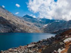
Perhaps the most striking warning comes from Gipan-Gath Lake near Sissu in Lahaul-Spiti.
The lake covered around 27 hectares in 1975. Today, its area has expanded to approximately 110 hectares—more than four times its earlier size. Its average depth is around 36 metres.
The dramatic expansion has been attributed to rapid glacial melting.
By surface area, the lake has now emerged as the largest lake in Himachal Pradesh. But its size is also what makes the situation potentially dangerous.
A breach could be triggered by a weakening natural dam, landslide, avalanche or earthquake. If that happens, enormous quantities of water and debris could rush downstream through the Udaipur region and potentially affect areas extending towards Jammu & Kashmir.
The warning becomes even more serious because Himachal Pradesh has now been categorised under seismic Zone VI, according to the information cited in the study. The combination of unstable mountain slopes, earthquakes and expanding glacial lakes creates a dangerous chain reaction: an earthquake can trigger a landslide or avalanche, which can destabilise a glacial lake, resulting in a sudden flood.
2,292 Lakes Identified Using High-Resolution Satellite Data
According to Dr S.S. Randhawa, disaster-control consultant to the state government and former Principal Scientific Officer at HIMCOSTE, the latest assessment was carried out using 5.8-metre-resolution LISS-4 satellite data based on 2023 imagery.
The study found 2,292 glacial lakes in the Sutlej basin.
Earlier assessments using 23.5-metre-resolution LISS-3 satellite data had identified 242 lakes in the Chenab basin, 93 in the Beas basin and 38 in the Ravi basin.
The scale of the threat therefore goes far beyond a handful of known dangerous lakes.
Not every glacial lake is necessarily hazardous. The real concern lies with lakes that are rapidly expanding, have unstable natural dams or are located in terrain vulnerable to avalanches, landslides and earthquakes.
That distinction, however, cannot become an excuse for complacency.
The Tibet Problem: India Cannot Monitor What It Cannot Reach
Hydro-engineer R.L. Justa has highlighted one of the biggest vulnerabilities in the Sutlej basin: only about one-fourth of the basin lies within Himachal Pradesh, while nearly three-fourths lies in Chinese-administered Tibet.
This means that treating the threat as a Himachal-only disaster management issue would be dangerously short-sighted.
A lake located hundreds of kilometres away on the Tibetan side can become a disaster for communities in Kinnaur, downstream Himachal and eventually Punjab.
India therefore needs a system capable of continuously analysing satellite imagery from across the border and identifying changes in lake size, water volume, surrounding glaciers and natural dams.
The warning is simple: the location of the lake may be outside India’s territory, but the consequences will not respect the border.
Fear Grips Sangla Valley Over Expanding Yarpabang Lake
The anxiety is already being felt on the ground.
Residents of Sangla Valley have expressed concern over the expanding Yarpabang Lake at Debar Kande in Sangla. The lake is approximately 550 metres long and 260 metres wide.
Its location has raised fears among local communities because a sudden breach triggered by an earthquake, avalanche or extreme weather event could send floodwaters towards settlements along the Baspa and Sutlej river systems.
Residents have urged the government and district administration to undertake immediate safety measures rather than waiting for a disaster to expose weaknesses in the existing system.
Their concern carries a stark message: people living beneath these mountains know that an event at a high-altitude lake can become a life-threatening flood hundreds of kilometres downstream.
Four Lakes Already Flagged as Highly Dangerous
The National Disaster Management Authority has identified four lakes in Himachal Pradesh as among the most dangerous and early warning systems are being installed to monitor them.
These include:
- Gipang Lake (Ghepal) in Lahaul-Spiti, with a reported surface area of 92.09 hectares.
- Vasuki Lake in Kullu.
- Baspa Lake in Sangla Valley, Kinnaur, situated at an altitude of around 15,465 feet and covering 18.88 hectares.
- Kalka Lake in Kashang Gad in the Sutlej basin, covering approximately 27.89 hectares.
The existence of early warning systems is important—but monitoring a lake is not the same as eliminating the danger.
Authorities must know how quickly a lake is expanding, how stable its natural dam is, what lies in its potential flood path and how quickly communities downstream can be warned and evacuated.
Himachal Has Already Seen the Sutlej Turn Deadly
The threat is not theoretical.
Himachal Pradesh has experienced the destructive power of sudden floods in the Sutlej basin before.
During the floods of July 31 and August 1, 2000, the Sutlej rose nearly 60 feet above its normal level. Around 200 kilometres of NH-22 were affected, while 20 bridges and 22 cable crossings were washed away. The disaster claimed 135 lives and caused estimated damage of around ₹1,466 crore.
Five years later came another warning from across the border.
On June 26, 2005, the Sutlej flooded after the breach of Parchu Lake in Tibet. Around 10 kilometres of NH-22 between Wangtu and Samdo were washed away, along with 10 bridges and 11 ropeways. Government and public property suffered losses estimated at approximately ₹610 crore.
The 2005 disaster demonstrated something that should not be forgotten: a lake in Tibet can become a flood disaster in Himachal Pradesh.
The Question Is No Longer Whether the Risk Exists
The Himalayan landscape is changing rapidly. Glaciers are retreating, new lakes are emerging and existing lakes are expanding. At the same time, Himachal Pradesh remains highly vulnerable to earthquakes, landslides and avalanches.
That combination is a recipe for cascading disasters.
The immediate requirement is therefore not another study sitting on a government shelf. It is a permanent, technology-driven warning and response system.
Authorities need to:
- continuously monitor vulnerable glacial lakes through high-resolution satellite imagery;
- identify rapidly expanding lakes and unstable natural dams;
- map precise downstream flood routes;
- install and maintain reliable early-warning systems;
- establish evacuation plans for vulnerable villages;
- conduct regular disaster drills in Kinnaur, Lahaul-Spiti, Kullu and other exposed areas;
- strengthen communication networks in remote valleys; and
- develop mechanisms to assess lakes located on the Tibetan side of transboundary river basins.
Most importantly, authorities must treat the Sutlej, Chenab, Beas and Ravi basins as interconnected disaster systems rather than administrative boundaries.
A Disaster Waiting for a Trigger
The most frightening aspect of the emerging threat is that the lakes do not need to “explode” on their own.
A single earthquake could trigger an avalanche.
An avalanche could displace millions of tonnes of water.
A landslide could weaken a natural dam.
And within minutes, a remote glacial lake could turn into a devastating torrent racing down a mountain valley.
For communities downstream, there may be little time to react.
The 2,292 lakes identified in the Sutlej basin should therefore not be viewed simply as a scientific statistic. They are a warning about a rapidly changing Himalayan environment and the enormous consequences of being unprepared.
The water is already there. The glaciers are changing. The lakes are expanding. What remains uncertain is when—and where—the next trigger will come.